I have been a bit lazy
lately about updating the blog, although, to be fair, we have had very
intermittent mobile coverage for the last month. Bill left off at Top Springs in NT, basically
a tiny spot in the middle of nowhere. We
moved on across the Buchanan Hwy, dodging suicidal cows who seem to decide at
the last minute to cross the road just in front of the car. The only other remarkable feature of this
trip was the fields of termite mounds that changed colour from dark red to pale
red, grey and almost white as the soil underneath them changed.
We spent a night at Long
Reach Waterhole south of Newcastle Waters.
It is a pleasant campground on the edge of a large waterhole with lots
of birdlife – Pelicans, Egrets, Darters, Herons and Jabiru. We backtracked a bit the next day to visit
Newcastle Waters, a historic township that was once the centre of cattle
droving in NT. In 1956/57, 97% of cattle
movements in the NT were by droving. By
1968/69, 95% of cattle were moved by truck.
As droving died, so did Newcastle Waters.
 |
| Long Reach Waterhole, NT |
 |
| Jabiru Stork, Long Reach Waterhole NT |
 |
| Monument to Cattle Drovers, Newcastle Waters NT |
We headed south to Tennant
Creek, and spent a night in a caravan park. They had an interesting and amusing
campfire entertainer “Little Jimmy”, a local aboriginal who was explaining
some bush medicine and bush tucker, including a very nice native lemon grass
tea, and some of the best damper I’ve ever tasted (similar to bannock for you
Canadians reading this).
 |
| Old Telegraph Station, Tennant Creek NT |
The next day we headed
across NT to the Queensland border, with fires burning along much of the
highway. We did little stopping, apart
from Mt Isa for a couple of days, as we had travelled through this area twice
before, and wanted to get up Cape York before the end of September. We had mail forwarded to the Post Office in
Mt Isa, but for some unknown reason it took from the 23rd of July to
the 30th to get to Mount Isa. Our mail was then sent back as
undeliverable on the 3rd of August, well short of the 14 days they
are supposed to hold it. Thanks for nothing, Australia Post.
One interesting and amusing
thing we saw in Mt Isa was a lovely quilt show by the local Quilters Guild. All of the quilts but one were machine
quilted. When I asked about hand
quilting, the ladies didn’t know anyone who still did it. Quote “They used to teach it at TAFE, but not
anymore”.
We headed north and east
via Hughenden (the dinosaur centre) and Porcupine Gorge, a beautiful little
National Park about 60 kilometres north of Hughenden. The campsites were on the
flat above the gorge and you walked down to it.
There was a huge natural pyramid shaped rock, and small swimming holes
in the river. And the days were warm
enough to swim again, although the nights were still very cold.
 |
| Dinosaur Museum Hughenden, Qld |
 |
| Pyramid Rock, Porcupine Gorge Qld |
We saw one other
interesting camp set up here – a motorcycle towing a tiny camper trailer that
held an alarming amount of stuff – picnic shelter annex, table chairs, camp
stove, fridge, food, solar shower and shower tent. I could not figure out where they put all
that stuff and I had to wonder just how hard it was to tow.
We continued on to
Atherton, a beautiful green little town in the Tablelands. We got the truck serviced in preparation for
our trip to Cape York. I also had to
spend about half a day online booking all the National Park campsites in
advance, as they had changed their booking system this year. You must book in
advance, can’t self-register at the parks as you used to. Very difficult as there is little internet
reception in the Cape, so you have to plan about three weeks ahead. And it does not allow for any changes of
plan. On top of that, they had changed
all the names of the parks since last year, so Lakefield NP is now Rinyirru NP
and Mungkan Kandju NP is now Oyala Thumotang NP (don’t ask).
We also decided to book ourselves
and the truck on the sea freighter back from Seisia (near the tip of Cape York) to
Cairns, so if the roads are as horrible as people say we only have to drive one
way. Other people we know have done it
say it is fun and the food is supposed to be good.
We headed out of Atherton
via Lake Tinaroo and Lake Barrine. The
road was very beautiful; narrow, steep, and twisty with lots of construction. The scenery is stunning and verdant green,
with a patchwork of farms and houses between the tropical rainforest. It was lovely to be out of the red dust and
back into the greenery for a change.
We stopped in Cairns for a
couple of days and left our bicycles and some extra gear with friends Gaynor
and Ashley. The bikes have taken a
battering on the back of the truck and we thought the Cape might be the end of
them, so we let them have a little holiday.
Our drive to Cape York
started up through the beautiful green rainforest of Daintree National Park. (
I know it is repititious but it is so long since we’ve seen lots of green
plants). We crossed the Daintree River on the ferry and
made the essential stop at the Daintree River Ice Cream Company for lunch. We
sampled the day’s four special flavours – raspberry, passionfruit, wattle seed
and coconut, all grown on the property. Their beautiful grounds were lush with
blooming tropical plants and brilliant blue Ulysses butterflies. After lunch we
continued up the “Bloomfield Track”, a narrow, very steep and twisty gravel
road with lots of potholes that was probably navigable by a careful two wheel
drive, but was quite exciting enough for us. We stopped overnight at Ayton and
the Lion’s Den Pub on the Bloomfield track, and two days later were in
Cooktown.
 |
| Beautiful Gardens, Daintree River Ice Cream Company (above and below) |
 |
| Jade Vine, Lion's Den Pub, Bloomfield Track Qld |
 |
| Cassowary, Daintree National Park Qld, Bloomfield Track |
We got to Cooktown 18
August, and we catch the freighter from Cape York the 17 of September, so we have
lots of time to stay and investigate the cape. We spent a few days seeing the
sights of Cooktown – the botanical gardens, historic cemetery, community
swimming pool with early morning length swimming, the recently refurbished
grassy hill and lighthouse, as well as the lighthouse south of Cooktown at
Archer Point.
 |
| Lighthouse, Cooktown Qld |
 |
| View from Lighthouse, Cooktown Qld |
Leaving Cooktown we left
the pavement behind and headed north to the little town of Laura. On the way we stopped at Split Rock Gallery,
one of the many aboriginal rock art sites that are scattered over the southern
York Peninsula. We also stopped at the
Laura Arts and Cultural Centre, which has a vey good display of the history of
the area.
We camped that night at
Jowalbinna (Dingo’s Ear) Station, a station and campground about 40 kilometres
from Laura. The original owner, Percy
Trezise, found many long forgotten rock art sites on the property in the
1960’s, and his sons currently run the station and tours to the art sites. We did a day tour with his son Matthew, a
fund of local information, and saw many beautiful “galleries” as whites call
the rock art sites.
 |
| Aboriginal Rock Art, Jowalbinna Qld (above and below) |
 |
| Pancake Breakfast, Jowalbinna Bush Camp, Qld |
After leaving Jowalbinna,
and our kind campground hosts Richard and Maree who fed us a pancake breakfast
in rerturn for us providing the maple syrup, we travelled to Lakefield NP. The first of our “sight-unseen” pre-booked
campsites was a delight. Six Mile
Waterhole was a one campsite campground – we had it all to ourselves, as well
as the waterhole with Brolgas, Egrets, a Royal Spoonbill, Ibis, Herons, Burdekin
Ducks and wild pigs in the early morning.
We also camped at Kalpowar Crossing, a bigger campsite that overlooks
the Normanby River. Here we saw our
first Cape York crocodile, but he was just a little freshie sunning himself on
a rock.
 |
| Brolgas, Six Mile Waterhole, Lakefield NP Qld |
 |
| Freshwater Crocodile, Lakefield NP Qld |
After three days we
continued up the Cape to Coen, where we camped overnight at the pub. Great
value -- $15 for a powered site.
Our next destination was Chilli
Beach in the Iron Range NP. We stopped
overnight on the way at Kaanjungaachi, an aboriginal run campground on the
Wenlock River. A herd of about 12-15 wild pigs ran across the road and nearly
under the truck as we drove in.
The next day we continued
on to Lockhart River, an aboriginal community with a wonderful art centre where
I bought a print that was very similar to some of the rock paintings at
Jowalbinna. My arts friends would be
interested to know that the arts centre is a major community resource, and many
people come there to paint and do printmaking.
Despite being located in a run down, former health centre and the
community strongly supporting the art centre, the state government is unwilling
to give them a long lease and their tenure is uncertain. Nice to know that the arts are treated with
equal disdain in all states, and large cities as well as tiny communities.
The road through Iron Range
NP had been forest and more open sort of heathlands, with quite a few fires
burning off the undergrowth here as well.
As we came across to the coast, however, remnant rain forest appeared as
we neared Chilli Beach. We camped for
three days, just back of the beach in the trees, and spent our time exploring
the white sand beaches fringed with coconut palms. The southeast trade winds blew strong and
constant, and we were glad of the protection of the trees.
 |
| Chilli Beach Sunrise, Cape York Qld |
 |
| Chilli Beach, Cape York Qld |
Of course, swimming was
discouraged (crocodiles again) and the beach had an incredible amount of
plastic rubbish, old thongs, plastic bottles, tubs, pails, crates, shoes, and
broken unidentifiable bits. There was
masses of rope and netting, fishing floats, umbrella handles, knife handles, a
plastic chair, glass bottles, bits of wooden crates, docks or piers, huge
commercial size LPG tanks… The most amazing thing about this was that we were
there at the beginning of September, and in August there had been a massive volunteer
clean up of the beach that removed over 5 tons of rubbish!! Horrible to think how much junk we dump in
the sea – and this is where a lot of it washes up.
We zigzagged our way north
up the peninsula. To Portland Roads, a tiny
fishing village with crystal clear blue-green water and a small café
overlooking the bay; Merluna Station
with fresh grapefruit from their trees and a couple who run bow-hunting safaris for
wild pig. The pigs are feral pests and
hunting is very popular. They kindly
gave me a few boars’ tusks to see what I could do with them for jewellery.
 |
| Portland Roads, CapeYork Qld |
 |
| Merluna Station, Cape York Qld |
Next stop was Weipa, a bauxite-mining
town with a wonderful Woolies grocery store (you really do appreciate the finer things
when you’ve been bush for a few days) and an interesting tour of the local
bauxite mine – lots of dust and big trucks.
They strip mine and revegetate everything. When the revegetation is finished, it is hard
to tell the mined from the unmined areas.
The miners are well paid and work 4 days on and 4 days off. You never saw so many four wheel drives,
boats, ATVs and trucks set up with cages for dogs for pig hunting. There is not much to do in Weipa in your
spare time if your don’t camp, fish or hunt pigs.
 |
| Bauxite Mining, Weipa, Cape York Qld |
We also saw our first Cape
York Estuarine Crocodile (salty) sunning himself on sandbar under a bridge north
of town.
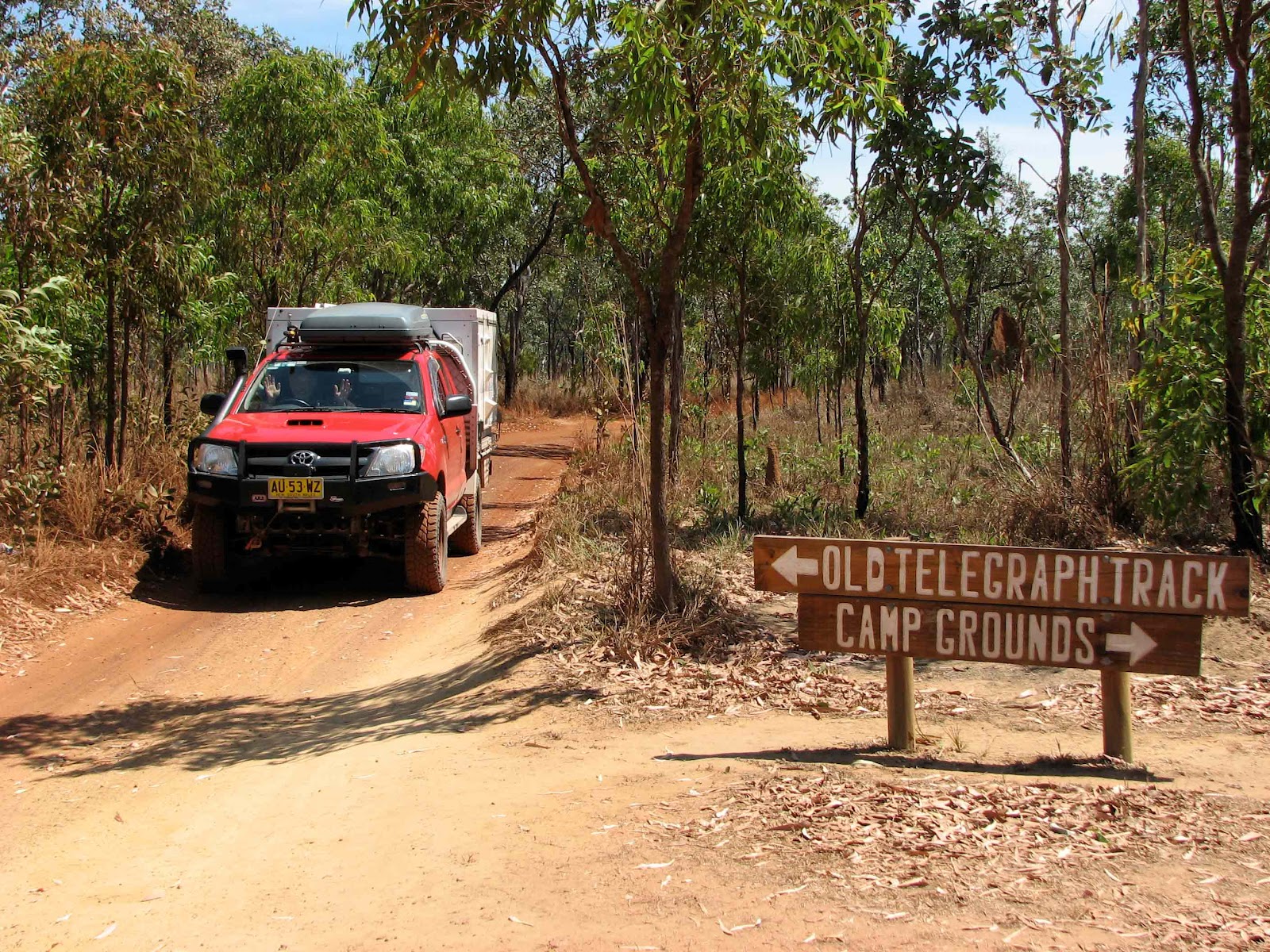
We headed north from Weipa
after a few days to the start of the Old Telegraph Track – a famous four-wheel
drive track to the tip. There are a
number of go-arounds and the Developmental Road for those who do not want
to do the OTT. We went into Palm Creek,
the first crossing . It had very steep
clay banks that then take a straight drop of about 1.2 metres into huge puddle
with old logs floating in it.. A bit
further on was a trash heap of lost truck parts, bull-bars, side steps, broken
lights, etc. We decided to give it a
miss and stick mainly to the Developmental Road Bypass.
 |
| Southern end of the Old Telegraph Track |
 |
| First Crossing (Palm Creek) Old Telegraph Track |
We went north on the bypass
road and spent two nights on the east coast again at Capt. Billy Landing – a
beautiful beach that was incredibly exposed to the wind with no shelter. The wind blew constantly and the truck was
coated with salt spray. There were bat
caves at the south end of the beach. Although
it was a lovely site, I was glad to leave to get relief from the constant
howling wind.
 |
| Capt Billy Campsite, Cape York Qld |
The road out was rough and
slow, and we were worried, as the truck has developed a couple of
problems. One of the diesel lines was
leaking slightly as it was nearly abraded through – Bill managed to patch it
with amalgam tape, and the front shock has developed a creaking/thumping sound
that is getting worse. We think it is
the bushings. (And hope that is all it is)
Next stop was Jardine River
National Park, where we swam in the clear blue pool at Fruit Bat Falls, and
camped 5 kilometres down the OTT at Eliot/Twin Falls. We had three days of
lazing around, swimming twice a day in small, clear waterholes, and generally
relaxing. Unfortunately we got bad news
on our first night there (Monday the 10th). We learned from other campers that a large
road building truck carrying blue metal (gravel to the Canadians) had an
altercation with the ferry. It ended up
with the truck in the Jardine River and the ferry out of commission for an
indefinite time.
 |
| Fruit Bat Falls, Jardine River NP Qld |
 |
| Eliot Falls, Jardine River NP Qld |
 |
| Twin Falls, Jardine River NP Qld |
 |
| Carniverous Pitcher Plant, Jardine River NP Qld |
We reached the Jardine
River Crossing on Thursday the 13th and the ferry was still not
running. We camped on the south side for
two nights, and finally got across on Saturday, along with a lot of other
delayed campers. Some vehicles had
tried to cross the Old Jardine River ford which is quite deep. A few were successful, but a number of very
wet, flooded four wheel drives were towed to the ferry and later seen at
various mechanics hoping for resuscitation.
We were supposed to put
ourselves and the truck on a the MV Trinity Bay, the freighter back to Carins
on the 17th, but luckily we were able to change that to the 24th
of September, as we lost two days waiting for the Jardine River ferry to be
fixed.
 |
| Superintending repairs on Jardine River Ferry |
 |
| Waiting for ferry after 5 days out of service |
 |
| First crossing of Jardine River in 5 days. Hooray!! |
We are now camped at
Loyalty Beach, a pleasant commercial camp about 40 kilometres from the tip of
Cape York, the northernmost point in Australia.
Bill is on a fishing charter today, and tomorrow we are taking a tour of
Thursday and Horn Islands, two of the more accessible islands in the Torres
Strait. We hope to drive up to the tip
on Thursday. After a little more looking around, we will be heading south by
freighter to Cairns on Monday the 24th and then back down coast
towards Sydney.
 |
| Sunset Loyalty Beach, Cape York Qld |