We are safely
and happily home from New Zealand. A few
comments on the final days of our trip follow.
The morning
we left for Dunedin, the Highway from Oamaru was closed due to snow. Not having much else to do we wandered around
Oamaru stopping for coffee and doing a bit of lackadaisical shopping. Around noon the road was finally opened and
we were on our way.
 |
| The Boulders at Moeraki |
We made a
stop at Moeraki and went to see their big tourist attraction of some odd, rounded
boulders on the beach. It was very cold
and windy, but quite a busy tourist site despite the weather. A bit further south we turned off to the
Moreaki Lighthouse at Katiki Reserve. It
was blowing a gale, with occasional showers and wind that threatened to push us
off the clifftops. But we went out to
the penguin sanctuary past the lighthouse and saw the rare Hoi-Ho or Yellow-eyed
penguins, as well as a lot of seals or sea lions napping on the grassy headland.
 |
| Hoi-Ho or Yellow-Eyed Penguin |
As we
headed into Dunedin, the road was lined with snow and the pavement was
slushy. Snowploughs (I hadn’t seen one
of those in years) were pushing the slush around and spreading grit. They don’t use salt on the roads here which
is probably better for the cars, but drivers complain about the grit instead.
It was
windy and very cold most of the time we were in Dunedin, so we spent most of our
time in museums. The Toitu Otago
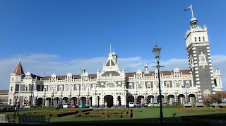
Settlers Museum near the wonderfully ornate train station was one of the best museums we saw in
New Zealand. It traced the history of
settlement and development in Dunedin and Otago. The scary part was the more modern displays
from the 1940s to the 1980s, where everything was familiar. (wringer washing
machines anyone?) Bill was particularly
taken with a big display of computers from 1950’s onwards.
 |
| Flemish Renaissance Style Train Station Dunedin |
We tried to
get a tour of the Cadbury’s Chocolate Factory, but it was closed for
maintenance. Instead, we visited Olveston
House, a mansion that has remained virtually unchanged since the 1920s and had
been donated to the city totally furnished as an example of life (at least,
life for rich people) in the early 20th century. We booked for the last tour of the day, and
as we were the only two there, got a very detailed private guided tour of the
house. I enjoyed the tour very much, and
a grand home that needed 7 servants to run it was a slice of a life that we will
not see again.
 |
| Queenstown |
Our next
stop was Queenstown, where we had booked a day tour to Doubtful Sound, a very
large and dramatic fiord southwest of Queenstown. The trip started at 6:45 with a 2 1/2 hour
drive to Lake Manapouri, where we took a 45 minute boat ride across the lake to
another bus. This bus drove us on an
isolated gravel road, narrow, steep and twisting with no guardrails to Deep
Cove on Doubtful Sound. This road was
built to facilitate the construction of the Manapouri generating station. It runs from the south side of Manpouri Lake to
Doubtful Sound, and is not connected to any other road.
 |
| Lake Manapouri |
The day was
pouring rain and cold, with patches of fog.
We stopped a couple of times to take photographs of waterfalls, but even
the dedicated photographers did not leave the comfort of the bus for long. The rain let up temporarily when we reached
Deep Cove and boarded the cruise boat for our trip along the sound.
 |
| Doubtful Sound |
The cruise
took us about three hours along the sound to the ocean and back again. Doubtful Sound is about 20 times larger than
Milford Sound and has steep green cliffs, lots of waterfalls, 9 metres of rain
a year and rain at the ocean surface 69% of the time. They don’t tell you that when you book the
cruise. The wind was cold, the rain was
often horizontal, it was mostly cloudy with occasional sunny patches near the
end, and lots of rainbows which seemed to get everyone excited.
We saw no wildlife to speak of, except for a
Mollymawk, a relative of the Albatross.
On top of that, the sound is not really a sound but a fiord. Sounds are formed when a river erodes a
valley and then the sea rises to fill it; fiords are valleys formed by
glaciation that the sea then fills. I
guess the name, which Captain Cook gave it as he doubted it was a good harbour,
could refer to the fact that it is doubtful if it is a sound. Bill thought the trip was great, but I am
doubtful if it was worth all the time and money for the short cruise that we
took.
Our last
big stop was Wanaka, a beautiful town in a mountain valley about an hour north
of Queenstown. Friends Peter and Belinda
from Sydney built a calm and spacious house in Wanaka and are spending quite a
bit of time there. Peter took us for a
short hike up Iron Mountain, a hill near the town that gives excellent views of
the surrounding countryside. The next
day he drove us about an hour north of Wanaka to the Matukituki Valley and the start of a track to the Rob Roy Glacier.
 |
| Wanaka |
The glacier
hike was not long, (about 4 hours return) but 99% of the first half was uphill
to a lookout where you can see the front edge of the glacier. The track followed a clear mountain stream
with pale blue-green pools lined with white sand most of the way up. The lookout point was cool and quiet, and gave stunning views of the blue-white glacier.
 |
| Rob Roy Glacier Track |
The last
few days of our trip were steady driving up the west coast of the South Island.
We stopped at many beautiful waterfalls,
the Fox Glacier (easier to access but a dirty brown colour rather than the
clean blue-white of the Rob Roy glacier), and saw something I have never seen
before, roundabouts with train tracks running through the centre of them. I’m glad we did not have to deal with any
trains when we were also negotiating auto traffic.
 |
| Near Fox Glacier |
On our last
day in the South Island we drove to a little seaside port called Havelock. Not too touristy, but with a large harbour
and marina, some decent eating places, interesting old architecture and an
excellent art and craft gallery. From
Havelock, we took the 30 kilometre Queen Charlotte Drive to Picton. It was the most beautiful seaside drive we
did in New Zealand. The road was a
narrow tunnel of green that twisted, cork-screwed and zig-zagged along the
coast of the Queen Charlotte Sound.
Homes clung to the cliffs below us or perched on points above green bays
full of anchored yachts. The early
morning fog lifted and we had brilliant sunshine for the whole drive. We stopped many times to take photographs and
I think to give Bill a rest from turning the wheel. I would have loved to have more time to spend
in the Queen Charlotte Sound area.
 |
| Havelock |
 |
| Queen Charlotte Sound Drive |
Once again,
we took the ferry back to the north island and headed for Auckland. We took Highway 1, The Desert Road, which
crossed a flat high plain of gold tussock grass and electricity pylons. It was dry, open and flat, and so different
to everything else we had seen it New Zealand.
The huge arc of the sky was spotted with cirrus and cumulous clouds
against a clear blue background. Later
the plain became more desiccated with red rock and furrowed gullies. Truly a lovely surprise on our drive.
 |
| Desert Highway |
 |
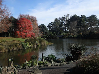
| Auckland Botanic Gardens |
 |
| Sculpture "Splayed" Botanic Gardens |
Our trip
ended with a non-eventful flight back to Australia. No idea where the next trip will take us.

No comments:
Post a Comment