Tuesday, 10 July 2012

Leonora to Broome WA

Bill’s last blog left us in Leonora WA, after we had crossed the Great Central Road.  Entering Western Australia, we began to see evidence of how pervasive the mining boom is, and all of the effects on the economy.


We stayed in a very inexpensive caravan park in Leinster, WA, another mining town.  Mining towns are usually great places to stay, as they are well funded and supported with good shops, parks, and pleasant facilities.  We had dinner in the mine “mess” at Leinster.  $15 a head for all the food you could eat at a huge cafeteria, and it was very good quality.  Choices included soup, salad bar, about 10 different mains, including vegetarian offerings, and about 20 kinds of dessert.  Apart from the travel and stress on family life, I think the main thing FIFO (fly-in, fly-out) mining workers will have to worry about is obesity.

We had a day of rain in Leinster, which was unusual and upset our plans (few as we have) a bit.  We were intending to go to Lake Mason, a former cattle station that is now a national park.  The rain, however, caused the township to close all roads (mainly 4WD) to the park and they gave no indication as to when they would re-open.  In the face of such uncertainty, we gave it a miss and took the highway west to Mt. Magnet.

From Mt. Magnet we headed north towards Newman. The impact of mining and exploration was even more visible here.  In a 200 kilometre stretch between Meekatharra and Newman, I counted the following vehicles:

Police Car
Pilot Car
Oversize*
Road Train
Truck
Car/Light Truck
RV/camper
1
8
9
41
13
16
14


*Two of the oversize vehicles were carrying huge mining dump trucks, which overhung their flatbeds on both sides and took up ¾ of the road.  They had 2 pilot cars and a police car driving in the wrong lane (towards us) to force cars onto the shoulder so the huge trucks could pass.  Trucks and road trains also often carried other trucks and caravans.

Following Oversize Vehicle into Tom Price

The volume and size of the traffic is awesome.  We spent most of the day passing road trains, an exciting experience in itself, especially if there is a strong cross wind.

Road Trains at Mt. Magnet Servo.  3 of 7 shown

In the next stretch of highway, we began to see another effect of the increased traffic.  The highway went through Bulloo Station, a very large cattle property.  There are no fences along the roads, and between Kumarina and Newman I counted over 20 cows on the roadside, killed by vehicles.  Made me very nervous as some were quite large and I think hitting a cow would be worse than a kangaroo.  It must be a big problem and not appreciated by both the drivers and the station owners, not to mention the cows.

Newman is another town riding the mining boom.   We stayed in a caravan park that also had a mining dormitory and mess.  The park was alive at 5:00 am with workers on a shift change, and mining and rail noises continued all night.  As one of the other campers said “Doesn’t this bloody town ever sleep?”

We had to buy a new tyre in Newman as we had ripped a chunk of rubber off one of ours somewhere.  This is when we found that the much-publicized guarantee on our famous brand name “tough, off-road tyres” only applied in major cities and was void if you took the tyres off the bitumen!!! Duh!!  Prices were much higher than Sydney, but we couldn’t be without a spare.

After Newman, we spent some time in Karijini, one of our favourite national parks.  It is in the Hamersley Ranges and has a beautiful selection of gorges to hike and explore.  We also gave swimming in them a go, but the water was even colder than Bongin Bongin Bay in winter.  Swims were very short.  Photographs cannot do justice to the scale of the scenery here – the steepness, depth and red colour of the gorges, the immensity of the sky over the plains where only the horizon stops your view, the clarity and number of the stars in the incredibly black sky at night.
Bill with termite mound at Karijini National Park

Hamersley Gorge, Karijini National Park


Hamersley Gorge, Karijini National Park
Kalamina Gorge, Karijini National Park

Kalamina Gorge, Karijini National Park (find Billy)
From Karijini we headed north to Millstream/Chichester National Park, supposed to be a wet tropical oasis in the Kimberley.  We were very much looking forward to this, as the weather had been unusually cool, with night temperatures often down to 1°C and day temperatures 12 -15° rather than the 20°+ you usually get this time of year.

Millstream was lovely and warmer than further south.  It has a series of palm-fringed pools that are home to flocks of galahs and corellas.  Swimming (warmer than Karijini but still not balmy) and kayaking are popular.  We also did a great hike from Python Pool in the north part of the park along an old camel track to Mt. Herbert.  We left our bikes at Mt. Herbert and then drove to the start of the hike.  It was a three hour hike, uphill all the way, but when we got to Mt. Herbert we had an incredible 15 minute downhill ride along the road back to the start.  Best part of the hike.
Millstream Chichester National Park from Old Camel Track
Palm Grove,  Millstream National Park

Sturt Desert Pea, Camel Track, Millstream National Park

After Millstream we travelled through the booming mining towns of Dampier (where we camped in earshot of the iron ore trains that shunted all night) and Port Headland.  From there we headed east to Barn Hill campground on Thangoo Station (350,000 hectares).  This is a private campground on a long sand beach interspersed with rock points, about 1½ hours west of Broome.  The setting was beautiful, and we had some nice runs along the beach and swimming when the tide was high. Tides here are immense, like everything else.  The water's edge can be 200-300 meters further out at low tide, and the beach is totally different.  There were also lots of rock pools to explore at low tide, with fish, crabs, anemones, etc. etc. The campground  also had its own version of the pinnacles – see photo.  Pity that they crammed people in like sardines in the campground.

Rocky Headland, Barn Hill Campground

"Pinnacles"  Barn Hill Campground

We are now in Broome for a bit of a break from travelling and to catch up on chores, repairs and shopping.  For example, one of the gas struts on our camper was leaking.  We bought a new pair in Adelaide, but were unable to install them, as the end fittings on the new ones are different to the old ones.  The slide-on manufacturer mailed us some adaptor ends, but they reached Whyalla after we left.  The caravan park in Whyalla kindly mailed them back to Mona Vale, where the friend who forwards our mail (thank-you Lindy) re-sent them to us in Broome.  So the struts we purchased in Adelaide 25 April are finally installed 7 July in Broome.  Patience is a virtue.

We are staying in Broome Caravan Park, 5 kilometres out of town.  It is an older park and not too exciting, although it does have a 25 metre (unheated) lap pool.  It is situated near a highway and next to the speedway, so we got to listen to roaring engines for 4 hours on Saturday night.  We managed to hit Broome not only in peak summer season, but at the start of WA school holidays, so there was very little accommodation available at the last minute.

Shopping in Broome is also interesting.  Bill wanted a couple of wine casks but they are not sold anywhere in the Kimberley – part of an effort to discourage aboriginal drinking.  It has the side effect of discouraging drinking in poor retired people as well, or forcing them to buy more expensive bottled wine.  Despite this, he likes Broome.  He very chuffed to be taken for a local yesterday -- albeit by a Queensland.  I put it down to his very daggy “bushie” hat (see photo with termite mound)

We have seen “ the stairway to the moon” (see photo) – an illusion of a ladder or stairway on the wet sand that occurs at full moon and low tide.  It was a beautiful natural spectacle but with a  couple of kilometres of rough sand dunes jam packed with cars, people, dogs, etc.,  all trying to get a glimpse of the 20 minute event or the perfect photo, it was somewhat less pleasant than I anticipated.  Broome’s population of 12,000 swells to over 70,000 in high tourist season, and I think all of them were trying to watch stairway to the moon with us.  Tomorrow night we are attending a big cultural event "The Reef 2012 Tour" Concert with Richard Tongetti.  A little change from all our "bush bashing".

Stairway to the Moon, Broome

Stairway to the Moon, Broome
From here we are heading up to Cape Leveque, then to Derby and a flight over the reversing falls, and across the Gibb River Road.  Lots to look forward to.

Wednesday, 20 June 2012

The Outback Way


Hello again from the middle of Australia. We are now in Western Australia sitting in the enclosed camp kitchen of a mining community caravan park - avoiding the rain. We plan to eat out in the "Mess" tonight ($15.00) with the mine staff. There is 3G phone reception and hence Internet service.
This is quite a change from the desert we have just come from, where the daytime temperatures are in the mid 20's C and nighttime temperatures of 4-6 C, with red sand and dust everywhere. But isn't this why we travel? To experience all the varieties of life on this planet - continent by continent. Enough philosophy!
Red Bank Gorge

Ormiston Gorge
From Alice Springs we went out to the West MacDonnell Ranges and spent 6 days visiting the various gorges, walks, and waterholes from our base at Red Bank Gorge NP. Most of the gorges here have permanent waterholes of some sort. See the pictures above.
Bobbie - Gorge rafting
Bill - Gorge rafting

In one gorge we took our Li-los (air mattresses) and paddled up the gorge thru the freezing water pools between the gorge walls, until stopped by a very narrow step, where we could not feel the bottom of the pool under foot, and did not like the look of the frayed rope required to lift you into the next pool.

From the Gorges we went on to Palm Valley.
Here we did some REAL 4 Wheel Driving along the river bed and through it in some places into the valley itself. Four kilometres took 30 minutes driving. Both the driver (Bobbie) and the Toyota HiLux survived.
Palm Valley
Next we played tourist at Uluru (Ayers Rock) and Kata-Tjuta (The Olgas) where we walked around the Rock and watched a sunset over these remarkable natural landmarks. Feral camels were encountered on the way to the Olgas. Pictures below again.
Feral Camel
Kata Tjuta (The Olgas)

Feral Camels


Uluru (Ayers Rock)
By then we had had enough of the cold desert nights and barren landscapes. To escape, we decided to take a shortcut. However this involved even more desert. The shortcut is called "The Outback Way". It goes from Cairns in Queensland to Perth in Western Australia, in an almost direct path. Unfortunately the segment we needed involved 1,100 kilometres of unsealed road (gravel/sand/rock) .
Great Central Road -The Outback Way
We crossed this in 3 days of busy driving, staying at the road houses (Warakurna and Tjukayirla), along the way. The highlight of the trip was a tour of the Meteorological station at Giles (next to the Warakurna roadhouse) our first stop. Here we saw the 9:00am weather balloon launch (done 2x daily - soon to be computer automated) and the remains of the first ballistic missile (Blue Streak) launched from Woomera, Australia's WWII missile range. We also purchased another aboriginal dot painting there (we have a small collection) See proof of our visit below.
Blue Streak Rocket wreck
Weather Balloon launch - Giles WA

Bobbie was reminded again today of her theory that the geology of Australia consists of two kinds of soil:
1.  Deep, soft sand which will not hold tent pegs, or
2.  Half an inch of gravel or topsoil, overlaying solid rock or extremely compacted rock and gravel which bends nearly all tent pegs to pretzels.
The only place we have ever been that dealt properly with this problem was a caravan park in Denham,
WA near Monkey Mia. They provided a drill to make holes for tent pegs. Leinster soil (where we are camped this evening), is half inch of gravel with solids underneath. 


State Hotel - Gwalia
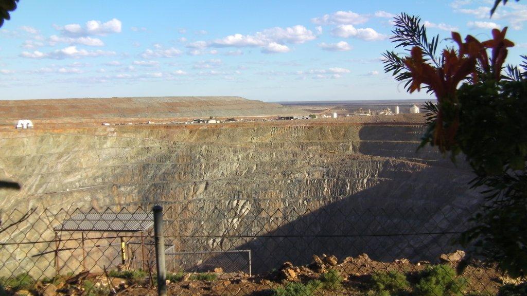
We came out of the desert at Leonora. Here we spent 2 days recovering and cycled out to Gwalia (Sons of Gwalia goldmine) which was initially opened up by Edgar Hoover (later president of USA) in 1895 when he was in his 20's. The mine town was abandoned suddenly in 1939 and much of the contents of the town and mine have been restored or retained for the curious. Very interesting "museum town". The mine has re-opened (with the increasing value of gold) and we also saw mining activity in the large open pit.
Gwalia - Gold mine pit
Today we left Leonora and are headed north to the warm weather. We have booked a caravan park in Broome for July 5-12 for some R&R and will work our way towards Broome via Newman, and Millstream Chichester NP. Till then...

Friday, 1 June 2012

Oodnadatta Track to Alice Springs


 I think our last blog finished about Kangaroo Island.  Bill wrote it and I think he missed a few of the choice things that happened, so I will fill in a bit.

We had some trouble with out airbag suspension system on the truck before Kangaroo Island, which took about 2 days to sort out in Adelaide.  It was complicated by the discovery that some dodgy repair work had been done on the system in Sydney that we were not aware of.  Being on the road makes it very difficult to follow up on these things;  you just have to get it fixed and pay the price.

Then we had a service done on the truck after we got back from Kangaroo Island, and the Toyota dealer thought there was a problem with one of the fuel injectors.  They were supposed to send some computer information about it to Toyota, but they didn’t do it correctly.  We had to have the same thing done in Whyalla, and it turned out they couldn’t send the file to Toyota for some unknown reason.  We finally got this sorted out in Alice Springs, three weeks later.  Toyota Service in SA has been somewhat less than optimal.  The service in Alice Springs seems better.

Anyway, none of this stopped us, and after Kangaroo Island we travelled to Mt. Remarkable National Park in the southern Flinders Ranges.  This is a lovely park with good-sized campsites and hot showers!!  The weather was comfortable but the nights were cool.  We stayed a few days, got to know the friendly emus, and did some hiking to Hidden Gorge and climbed Mt. Remarkable.  The climb is not difficult or technical, but very tiring as it is one continuous upward climb.  The view at the top is obscured by trees, but the views on the way up are excellent.
View From Mt. Remarkable
Friendly Emus Mt Remarkable
From there we spent a few days in Whyalla, relaxing in a caravan park, recharging batteries, buying food, waiting for forwarded mail and doing laundry.  The Caravan Park was on a nice looking beach on the Spencer Gulf, but it was extremely shallow when the tide went out. The sand was only on the edge and the rest was mud and weeds.  I didn’t swim.  We did, however, get to meet the Whyalla dolphins in the harbour.   They follow all the sport fishing boats into the dock, and laze around so close you could reach out and touch them from the pontoon.
Camping on Spencer Gulf at Whyalla 
 Short diversionary note about the trials of life on the road -- it is surprising when you travel how your standards of cleanliness change.  Clothes that would hit the laundry bag at home are examined carefully, and if they pass the smell test and don’t stand up by themselves, are declared clean.  Unfortunately, “clean” clothes do eventually run out and laundry must be done.  Clean is relative, of course, as most laundry done in caravan parks gets about 30 minutes in a lukewarm wash (if you are lucky) in a washer of dubious quality and vintage.  I never thought that my washing machine would be one of the things I missed the most about home.

From Whyalla we headed north the Flinders Ranges National Park, where we camped for 2 very cold nights and did some more hiking up the Bunyeroo Gorge.  Not difficult hiking and not the best gorge or hike in the park, but still very pleasant scenery.  The last time we were in Flinders Ranges was October 2010.  There had been a lot of rain and everything was green.  This time it was very dry and the red dust was everywhere. 

We headed north from Flinders Ranges and stopped at Leigh Creek.  If anyone is planning to travel the Oodnadatta Track, this is the place to stock up as they have the best selection of food and you can fill up with good drinking water. Diesel prices are fairly good -- $1.78/litre.  (If you think that is bad, wait ‘til you get to Oodnadatta where diesel is $2.27/litre).  We found the flies becoming a nuisance here, and fly nets are the order of the day if you don’t want flies crawling up your nose and in your ears and mouth.  They are horrible.

Following the advice of some a couple we met, we spent a night north of Leigh Creek at Farina, a private campsite on a station.  In the early to mid-1900s it was a bustling town of 350;  now it is an abandoned ruin.  Some of the old stone buildings are being restored by volunteers and much of the history is presented in information bays.   Camping is in a grassy, treed area, with showers heated by a wood burning donkey heater.  All this for $5/person/night.  Excellent value and interesting history.

From there we made our way north to Maree up the Oodnadatta Track past Lake Eyre, following the route of the old Ghan Railway.  The railway went from Port Augusta to Alice Springs.  Along the “Track” (which is really a good gravel road) are numerous abandoned railway stops, bridges, bores, old settlements, and mound springs.  The mound springs are artesian water that forces its way up through the earth and builds up a hill or mound around itself.  The rail line followed a line of these springs, as they were the only reliable water sources through the desert.  It is a sad story, however, as this great engineering feat lasted for a relatively short time, and is now disappearing into the desert again.
Mound Spring along Oodnadatta Track

Beresford Bore Siding, old Ghan Railway Oodnadatta Track
Roadside Art at "Planehenge" along Oodnadatta  Track

Desert Sunset

Campsite at Algebuckina Bridge, Oodnadatta Track

We did a 2 day side trip from Oodnadatta to The Painted Desert and the Copper HillsillasHH, two beautiful areas west of Oodnadatta that have sand hills of cream, red, grey and ochre colours.  They seem to change as the light changes, and are very picturesque.  We did a short walk along the tops of some of the hills and the views were spectacular.

Painted Desert, West of Oodnadatta

We also learned about the “scent of the desert”, the Gidgee Tree which is a stunted, black-barked tree that grows in the streambeds.  It has a distinctive scent, which people associate with the desert.  Unfortunately, that scent smelled like bat guano to me, or as one of the locals put it, “dog piss”.  The tree is also known as “The Stinking Wattle”.  It is very strong, as the scent permeates the air far from the trees themselves.

We spent 3 days at Dalhousie Springs, which is the jumping off point for people crossing the Simpson Desert.  It must be desert crossing season, as in the few days we were there the travellers increased every day.  The other drawing card of Dalhousie is the spring, which is fresh water and varies in temperature from 34-46°C.   The spring is a giant natural hot tub, lovely for a quiet soak, but a bit warm for swimming.  Still, I hope the Green Prawns and Dawnbusters think of me in the 38° water as they swim at Mona Vale through July and August.

Dalhousie Springs

Dalhousie Springs natural hot tub 38 degrees C
 We did not go across the Simpson Desert as the track heads back east to Birdsville, and our next move was north and west via Mt. Dare and Finke to Alice Springs and Uluru.  After Mt. Dare and Finke we had planned to continue through the desert along the old Ghan line to Alice Springs.  Two days of very rough roads and corrugations changed our minds, however, and from Finke we headed out to Kulgera and the (paved) Stuart Highway north Alice.  On the way we camped one night at Lambert Centre, the exact geographic centre of Australia.  This is a marker in a clearing in the middle of nowhere, with a dunny of questionable vintage as the only amenity offered at the camping spot.  Still, it was an interesting and offbeat stop.

Lambert Centre, Geographic Centre of Australia

We are now in Alice Springs, in one of the 6!! Caravan Parks within a kilometre of each other near Heavytree  Gap.  This is also near the Todd River where all of the aboriginal “long grassers” sleep in the open.  I guess they like to keep all of us undesirable transients in one place.

Until next time.

Tuesday, 8 May 2012

Island of Kangaroos

We are now in Adelaide again after returning from Kangaroo Island. We spent 2 weeks there, when most visitors spend 3 days.
Kangaroo Island food.
The first 4 days on the island were in the largest town Kingscote - population 1100. We attended the island Seafood festival where there were we tasted wine, and ate Whiting, with salads, and cheese platters. Marron (Freshwater Crayfish), Oysters, and Lobster, and KIS (Kangaroo Island Spirits) cocktails were also available. All produce was from the island. Evening entertainment with keyboard / clarinet, Sax and impromptu soloists gave us a good introduction to the island locals.

Cape Borda Lighthouse
Another highlight of the island was our 2 nights in one of the cottages at Cape Borda lighthouse. It is at the far end of the island 55 kms from the nearest settlement. Even more interesting was Mick, the South Australia Parks Ranger responsible for the grounds, and the tours of the lighthouse. He was also responsible for firing the cannon at precisely 1:00 pm daily , a tradition from the late 1800 so that visiting ships might correct their watches after sailing across the roaring forties from Europe. We seriously think his 5 years in isolation at the lighthouse had affected his personality.
Koala
Blue Wren
Wildlife on the island was everywhere, and we had a great time taking their pictures.
Bobbie also found several beaches and was able to swim most mornings. She said it was no colder than Mona Vale Beach in Sydney.


 P.S. If you go there, make sure you have lunch at Chapman River Wines. Lunch platter displayed above.

Friday, 20 April 2012

Friday 20 April
Coorong National Park South Australia

Bill finished with us leaving the Rutherglen in Victoria and heading west.  We left our rather pedestrian caravan park in Bundalong and headed along the Murry River to Echuca. (Never did figure out how to pronounce that name).  We settled in for a few days of "urban tourism".

Echuca is a major caravan holiday site with twelve big parks in Echuca and Moama (just over the border in NSW).  The big deal in Echuca is taking a paddle steamer cruise on the Murray River, so we did.  We cruised on the Emmy-Lou, a wood-fired paddle steamer that used to be used for freight and towing timber, that dated from the early 1900s.  Although the cruise was relaxing and provided a lot of interesting history, I was disappointed that the Murray River at that point is more like a deep muddy ditch than a mighty river.  I was very interested, however, in the number of little paddlewheel boats that people have built or restored for private use.  There were also numerous huge houseboats for rent, with all the mod-cons including a huge hot-tub on the upper deck.

Small private paddle boat at Echuca

Commercial paddle steamer Canberra

The next morning we went for a bike ride on paths along the edge of the Murray that basically followed our steamboat cruise route to the junction with the Campaspe River.  This took about one third of the time that the cruise did. (Mainly due to the fact it was very cold and I was peddling as hard as I could to keep warm.)
After Echuca, we headed for the Grampians with a brief overnight stop at Melville Caves Campground.  This area in Kooyoora National Park was the hideout of a bushranger named Captain Melville.  We did an unexpectedly long morning hike (6K instead of 2) due to poor signage.  The rock formations were fascinating, however, and I was quite taken with the womens' toilet block in the picnic area that looked like modernist architecture colliding with a boulder.
Melville Caves, Captain Melville's Hideout (boardwalk added after time of  Captain Melville)
Womens' Toilet Block, Melville Caves
We then headed for  The Grampians National Park, via the pretty little country town of St. Arnaud, and Stowell, home of the Stowell Gift footrace.  We missed it by about a week.

 The Grampians are basically a huge pile of rocks that stick out of a very flat plain.  They probably attract so many visitors as they are one of the few interesting features in landscape.  The Grampians are a very old (late 1800s) and popular Victorian National Park.  They are also one of the few National Parks to have a lot of 4WD tracks running through the park.  (Although I'm not sure they need them as some of the so called gravel access roads were pretty rough.) We spent our time hiking and sightseeing, including a 12 kilometre hike around and to the top of Mt. Stapylton, which ended in a scramble up a short, narrow chimney to the summit.  On a more genteel note, we also walked down a very steep 750 metre flight of rock stairs to view the lovely Mackenzie Falls.  The Grampians also had the very civilized "bush showers" for any campers who cannot do without their daily shower. (A bush shower is basically an enclosure with a bucket which you raise on a pulley to have a shower.  You have to provide your own hot water).

Mackenzie Falls

Interior of The Grampians from Reid's Lookout
View over surrounding farmland from the summit of Mt. Stapylton

 After the Grampians we headed to the Coonawarra area of South Australia.  Although we had not yet consumed the spoils of our wine buying spree in the Rutherglen, we could not let a wine producing area, especially one with such nice reds, pass without sampling.  Unfortunately, sampling leads to buying.  We sampled and bought at Rymill, Redmann and Leconfield wineries.  Rymill was particularly nice as we had a coupon for a free bottle if you bought over $60 worth of wine. We camped at Bool Lagoon, a seasonal wetland that is one of the world listed RAMSAR Wetlands to protect migratory birds.  It was, however, low water time and much of the lagoon was dry.  We did not see many birds, but it was a quiet place to camp.

Rymill Winery,  Coonawarra SA

Bool Lagoon, Coonawarra SA
We made an overnight stop in Mt. Gambier to fill up on water, do laundry etc.  The caravan park we selected was one of the less expensive ones, but it was filled with little hoons on bicycles racing around the camp.  Turns out the BMX championships were being held in Mt. Gambier.  We did not stay to watch.

Since then we have travelled along the SA coast and are camped at The Coorong NP.  There is supposed to be 4 wheel driving on the beach here, but it is very narrow and boggy.  Bill was interested in having a go, but I chickened out.  Didn't want to be stuck without any help and the tide rising.  Even swimming looks ugly as there is a big gutter and dumpers on shore.  I haven't swum in over a month, but can't bring myself to go in.  We did a short hike to Chinaman's Well, a well from the gold rush days that provided water to Chinese travelling overland from SA to the Victorian goldfields.  They used this route to avoid the 10 pound head tax levied by Victoria on immigrants.  The well was built of local stone cut from the bottom of salt lakes and you can still see where the stone was cut.

Chinamans Well

Lid for the well cut in one piece from this sandstone lake bottom site
Thats all for now folks.  We are off to Kangaroo Island on Monday.